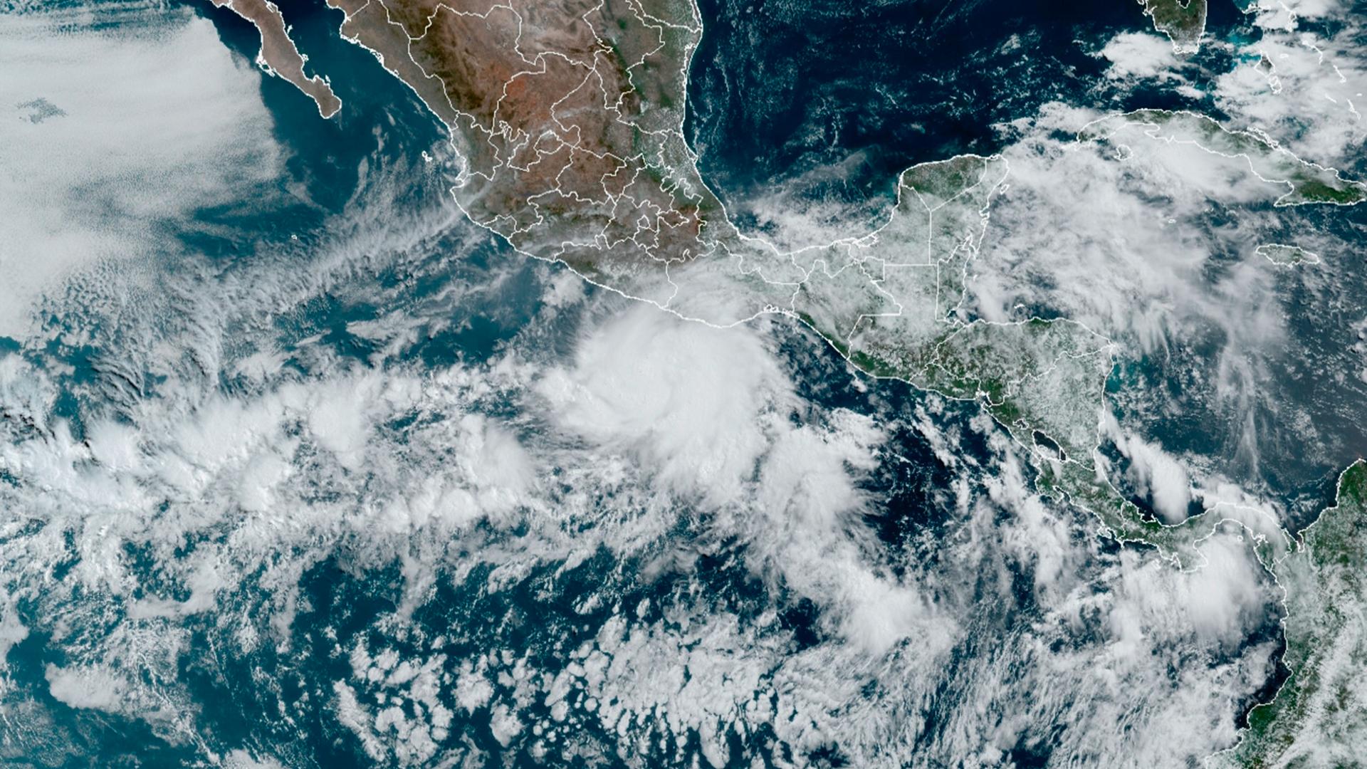
Torrential rains and sustained winds over 100 miles per hour ripped through Mexico’s Oaxacan coast as Hurricane Agatha made landfall near Puerto Angel on Monday as a Category 2 gale.
Mudslides hit at least two highways and electricity was knocked from many communities. At least 10 people were killed and 20 disappeared, as of Tuesday, according to the Oaxacan state governor.
“It rained really hard on Monday morning,” said Carlos Sánchez, who runs a community radio station in the municipality of Juchitán, a couple of hours up the Oaxacan coast. “There were serious floods in homes in lower-lying areas.”
Related: More migrants are attempting to cross into the US via the perilous Rio Grande
Videos shared over social media show buildings destroyed, roads out and homes flooded with pools of water — with residents working to keep things dry.
Hurricane Agatha has been downgraded into a tropical depression, but it’s still expected to bring heavy rains to the Yucatán Peninsula this week. It’s also possible it may reform as a new storm in the Caribbean in the coming days, heading east toward Florida.
Agatha was the strongest hurricane to ever hit the country in May. It went from tropical storm to Category 2 hurricane seemingly overnight.
“It is unique. It is rare that we would see a storm form this early and intensify this quickly. But it’s par for the course that we’ve been seeing in the last few years, with this rapid intensification from initial growth to mature hurricane quickly.”
“It is unique. It is rare that we would see a storm form this early and intensify this quickly,” said Jill Trepanier, a geographer and hurricane specialist at Louisiana State University. “But it’s par for the course that we’ve been seeing in the last few years, with this rapid intensification from initial growth to mature hurricane quickly.”
Related: ‘That news hit us like a bomb’: Asylum-seekers still in limbo after ruling to keep Title 42 intact
Trepanier said that there is one key factor driving the hurricane’s ability to get big fast: sea temperatures. They’ve been on the rise for decades. Now, of course, sea temperatures also fluctuate due to a number of factors, including weather phenomena like La Niña, which brings warmer water to the Atlantic and the Caribbean. That’s the case this year.
“The temperature right now, that I can see, is that the Gulf of Mexico and the Caribbean is about a half a degree to 2 degrees Celsius warmer than normal,” said Trepanier, while reviewing a Sea Surface Temperature chart updated daily by the National Oceanic and Atmospheric Administration (NOAA).
“But then, if you look at ocean temperature near the eastern seaboard, like New Jersey, the Carolinas, New York, because of the movement of the Gulf Stream, right now, it’s about 4 degrees higher than normal, Celsius. So, if a storm happens to make it up into that part, it’s going to intensify quickly.”
Related: Hundreds of feet in the air, Sonoran highliners face fears and find balance
Mexican meteorologist José Martín Cortés said that people need to be ready.
“All of the forecasts show that we are going to have above-normal tropical activity. A very active hurricane season,” he said.
If it is another above-average year, it would be the seventh in a row. The US National Oceanic and Atmospheric Administration reported last week that six to 10 Atlantic hurricanes are expected this year, and half of them major ones.
“As always, if you live near anywhere in the tropics from the months of May until December, you should have your eyes in the sky,” Trepanier said. “Be aware of things like rapid intensification. Just because it forms really close to the coast does not mean that it will not have the energy available to turn into something fierce. It does not have to have a long life to become a Category 4 hurricane.”
We’d love to hear your thoughts on The World. Please take our 5-min. survey.