Google: The world’s most powerful cartographer
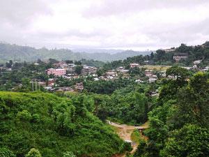
Image of Arunachal Pradesh by Flickr user rajkumar1220 (cc:by)
This story was originally covered by PRI’s The World. For more, listen to the audio above.
Just hours before China and India sat down for negotiations over a disputed territory called Arunachal Pradesh, Google Maps turned the area Chinese. The mountainous area close to the Tibetan border is governed by India, claimed by China, and had previously displayed Indian names on Google maps.
“One minute they were in Hindi and the next minute they were in Mandarin,” John Gravois, a writer for the Washington Monthly told PRI’s The World, “which was touchy because India and China have been fighting over this province for decades.”
The incident set of a volley of criticism against Google. According to Gravois, bloggers in India accused Google of conspiring with China on a kind of “digital invasion of Arunachal Pradesh.” Others blamed it on Chinese Hackers. Others believe it was simply an accident.
Arunachal Pradesh is just one of the many border disputes in which Google’s maps have become embroiled. “Google’s reach has become so vast that, whenever the corporation becomes involved in a geographical spat, it’s effectively an international incident,” Gravois writes for the Washington Monthly. “Border disputes have become a common vexation.”
A senior Cambodian official has criticized the company for its depiction of the Cambodian-Thai border, calling it “devoid of truth and reality, and professionally irresponsible, if not pretentious.” The company has been dragged into the Israeli-Palestinian conflict, after someone sued for allegedly misleading information about an Israeli town.
Google does its best to remain neutral on geo-political issues, but that neutrality is both nearly impossible and galling for some people. This month, Google announced that it was improving the accuracy of the borders inside Google Maps and Google Earth. For example, they replaced a solid yellow border between Ethiopia and Somalia with a dashed red border, to show that the line is disputed. Gravois points out that maps have always been used in conflicts and for power. He told The World:
Back in the day the most authoritative mapmakers were states and even superpowers. The British, they used maps to fuel their colonial expansion. Now, Google, by kind of taking the baton in becoming the kind of, the biggest mapmaker around has made its commitment to being a kind of agnostic cartographer even more difficult.
PRI’s “The World” is a one-hour, weekday radio news magazine offering a mix of news, features, interviews, and music from around the globe. “The World” is a co-production of the BBC World Service, PRI and WGBH Boston. More “The World.”
