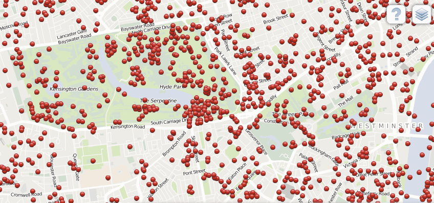
Bomb Sight: Interactive map shows where Blitz bombs fell on London
Bomb Sight is an interactive map that shows each bomb that fell on London during eight months of World War II.
Geographers in the UK have mapped the exact location of every German bomb that fell on London during eight months of World War II.
Bomb Sight, as the project is called, is an online, interactive map of current-day Greater London that shows every bomb as a red dot. There's information about what type of bomb it was, when it hit, and where Britain's defenses were.
The map also integrates geo-located historical photographs and testimonies from survivors, the BBC said.
It is based on official records that, until now, were only available on paper in the UK's National Archives. Taken between October 1940 and June 1941, they are evidence of just how relentlessly the Nazi air force bombed the British capital during the Blitz.
"When you look at these maps and see the proliferation of bombs dropped on the capital, it does illustrate the meaning of the word Blitz, which comes from the German meaning lightning," said Dr Kate Jones, a geographer who helped devise the project with colleagues from the University of Portsmouth.
"It seems astonishing that London survived the onslaught."
More from GlobalPost: Americans gather to remember those lost in Pearl Harbor
More than 40,000 people were killed in the Nazis' eight-month bombing campaign, which targeted 16 of Britain's biggest cities between September 1940 and May 1941. Around half the victims were killed in London, which at one point was bombed every night for 57 nights. Thousands of Londoners were evacuated or made homeless.
Bomb Sight's developers also plan to make an app available for Android that will detect where users are via their phone's GPS and show them any bombs that fell nearby.
See a preview video here:
We want to hear your feedback so we can keep improving our website, theworld.org. Please fill out this quick survey and let us know your thoughts (your answers will be anonymous). Thanks for your time!
