Seawater is infiltrating a nuclear waste dump on a remote Pacific atoll
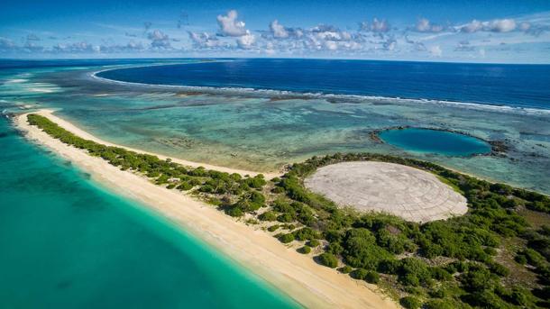
The Runit Dome on Enewetak Atoll contains radioactive soil, chunks of plutonium from misfired atomic weapons and other debris from the nuclear testing that took place there between 1946 and 1958.
Seawater is infiltrating the Runit Dome, an atomic bomb-waste repository on a remote Marshall Island atoll in the central Pacific Ocean, posing a potential risk of radiation exposure for the small, local population.
In the 1940s and ’50s, the remote coral atolls that make up the Marshall Islands were ground zero for US atomic weapons testing. Islanders who were evacuated from Enewetak Atoll were allowed to return in the 1980s, but the encroaching ocean is raising concerns about contamination from nuclear weapons waste. US experts insist its plutonium contamination levels are not dangerous.
The Marshall Islands are a huge expanse of more than 1,000 islands spread over 2,000 square kilometers. Enewetak Atoll is in one of the most remote parts of the Islands, located in the far west of the country.
“To get there is a feat in itself,” says Mark Willacy of the Australian Broadcasting Corporation, who traveled to the atoll to report on the situation there. “We had to hire an old prop plane and fly across 1,000 kilometers of open ocean and land on an old US military airstrip. It's a beautiful place. It's just extremely remote and extremely isolated.”
The island currently has a population of about 200 people. There is no work on the island so a lot of people move away. Air services and the barge that brings supplies are not regular, so “you really do feel like you're at the end of the Earth,” Willacy says.
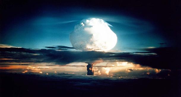
Bikini Atoll, which is probably the most famous site of the US nuclear testing, is about 300 kilometers east of Enewetak, but Enewetak had nearly double the amount of nuclear tests between 1946 and 1958. There were 43 nuclear detonations during that period, including some of the largest bombs ever tested — some so big they vaporized entire islands. An old NBC report from the 1970s during the cleanup of those islands made the point that it was the most toxic place on Earth, Willacy notes.

In 1977, about 4,000 US servicemen were sent in to clean up as many of the islands as they could. Over a three- to four-year period, they put about 85,000 cubic meters of radioactive soil and debris into a small crater (left behind by one of the blasts) and then capped it with a concrete dome about a foot-and-a-half thick.
When the dome was built in the late 1970s, climate change and sea level rise were not a factor, so the site was built right next to the shore on the ocean side of the island. The Marshall Islands, with an average height of six feet above sea level, is one of the most low-lying countries on the planet. In the intervening years, storm surges have driven sea water clean across some of the atolls.
“Now, seawater is penetrating the underside of the dome, because when they threw all this material into the old bomb crater, they didn't line it with anything,” Willacy says. “They were supposed to line it with concrete, but that never happened because of cost considerations. So, as the sea level has risen, the groundwater level has risen and therefore you have groundwater penetrating inside the dome, because a lot of this atoll is obviously sand [and] coral. It’s permeable material.”
Not only that, the United States, in a 2013 government report, warned that the dome could smash apart due to the increased ferocity of typhoons and other big storms. If the dome were to be breached, the government report warned, large quantities of radioactive material would leech out into surrounding waters. At the same time, the government has also said a catastrophic breach of the dome would cause no greater environmental damage to the outside environment than has already been caused by the bomb tests, Willacy adds.
“The lagoon formed by the Enewetak atoll — the second largest ocean lagoon in the world — has a lot of plutonium in the sediment at the bottom of it, and the United States government is saying, ‘Look, the dome serves a purpose, but if it was to be breached, we doubt it would create much more damage,’” Willacy says.
“Now, you talk to Marshall Islanders and they say, ‘Why build the dome in the first place? It’s obviously got plutonium in it; it’s highly toxic … and if it was to spill out, we're the people who would have to be evacuated once again from Enewetak, which is our island home,’” Willacy adds.
The Lawrence Livermore Laboratory, based in California, has been doing groundwater-monitoring tests at Enewetak and, in recent years, has installed a number of monitoring facilities, but there have been no moves to reinforce the dome, which could potentially cost hundreds of millions of dollars. “For the Marshall Islanders to do it themselves would be impossible,” Willacy says. “This is a small Pacific nation, quite impoverished by Western standards.”
The Marshall Islands government would like to see the United States take responsibility for what it sees as a United States problem, Willacy says. In 1986, however, the US government made a deal with the Marshall Islands, agreeing that the islands would take over running its own affairs.
“It paid the Marshall Islands about $150 million, and said, ‘Right, all deals are done. There’s no more claiming of compensation or anything like that,’” Willacy explains. “So, from the perspective of some in the United States government, there is no obligation to come back and clean up this dome or to fix it up. So, I think we're at a political stalemate and that's the problem.”
Editor’s note: Living on Earth contacted the Department of Energy’s Lawrence Livermore Labs, which has assessed the structural soundness of the nuclear dome, along with independent experts. The lab says external cracks don’t affect the solidity of the protective cover, but will be repaired during 2018.
This article is based on an interview that aired on PRI's Living on Earth with Steve Curwood.
We want to hear your feedback so we can keep improving our website, theworld.org. Please fill out this quick survey and let us know your thoughts (your answers will be anonymous). Thanks for your time!
