‘Space archaeologists’ and activists are using satellites to unearth history
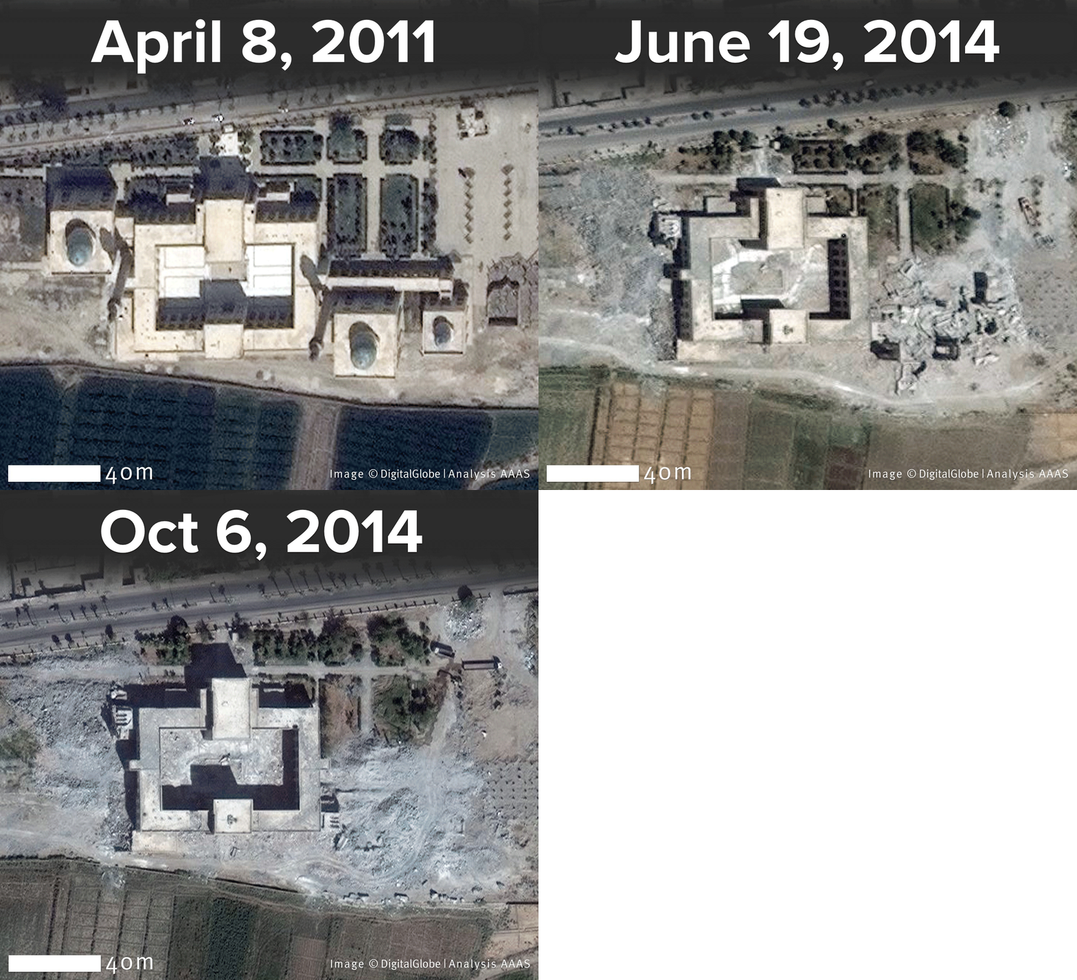
Satellite imagery reveals the ISIS-led destruction of the tombs of Uwais al-Qarani, Obay ibn Qays, and Ammar ibn Yasir in Raqqa.
Satellites are integral for modern communication, navigation and weather forecasting. But advances in satellite technology, however, are allowing for new political and archaeological applications.
“It's amazing … the questions that you can answer that you didn’t even know you could answer once you start digging in and exploring what the options are," says Susan Wolfinbarger, director of the Geospatial Technologies Project at AAAS.
Wolfinbarger has been using satellite imagery to track cultural crimes like the looting and destruction of culturally significant sites in hard-to-access parts of the globe.
“The destruction that we were seeing has not been just an ISIS phenomenon,” Wolfinbarger says. "That's something I can't say enough times. There was destruction happening across many sites long before ISIS entered the picture. … We’ve seen a lot of damage happening across the entirety of the the Syrian civil war. And it's not just a new phenomenon.”
Satellite imagery, which is now precise enough to highlight things as small as ten inches across, has been used to uncover previously undiscovered archaeological ruins. Sarah Parcak, a self-described “space archaeologist” has helped to uncover more than a dozen pyramids and 1,000 forgotten tombs in Egypt. Her latest satellite find is a potential Viking camp in Newfoundland — which would make it only the second settlement found in North America.
She’s currently working to develop a platform that would allow anyone to help in the search for cultural maps, potentially from their iPad.
“It's like Google Maps in that people are going to see imagery,” Parcak says. “Users will register, they'll be trained, and they'll then get to compare these different satellite images just like we do in the lab. They'll be doing good science and seeing if they can see anything — do they see site looting? Do they see any potential archaeological features? … There will not be any mapping data or GPS data connected to the images they're seeing because, of course, we have to protect the sites.”
But satellites aren’t just being used in modern-day archaeology. They’re also being used in political and humanitarian applications.
“A lot of the work that we do is in non-permissive environments. We work in a lot of conflict zones, we work in documenting things that are happening in countries where the governments probably don't want to let us come in and investigate,” says Wolfinbarger. “We've used satellite imagery to look for mass graves. We look at attacks on civilians, housing demolitions, a whole range of different human rights-related issues.”
And Wolfinbarger says the data collected by satellite imagery tends to be more respected and helpful than many other types of data collection, including eyewitness accounts.
“That is one of the great things that we can do with with satellite imagery because, you know, it's a very respected type of scientific analysis,” Wolfinbarger says. “It's date-stamped, it's location-specific and so we've used that in a number of different ways to counter propaganda that's going on….We used it during the conflict between Russia and Ukraine when Russia was saying that they weren't moving troops to the border, we were obtaining satellite imagery that was actually showing massive troops moving towards the border. So it's really great for being able to say ‘No, this is actually what's going on.’”
This article is based on an interview that aired on PRI's Science Friday.
